
America’s National Parks
Puzzle 01 · Northeast and Appalachians · Page 13 in print
Acadia
George B. Dorr, known as the father of Acadia National Park, declined any salary except one dollar a month as the first custodian of the national monument.
Jump to a word
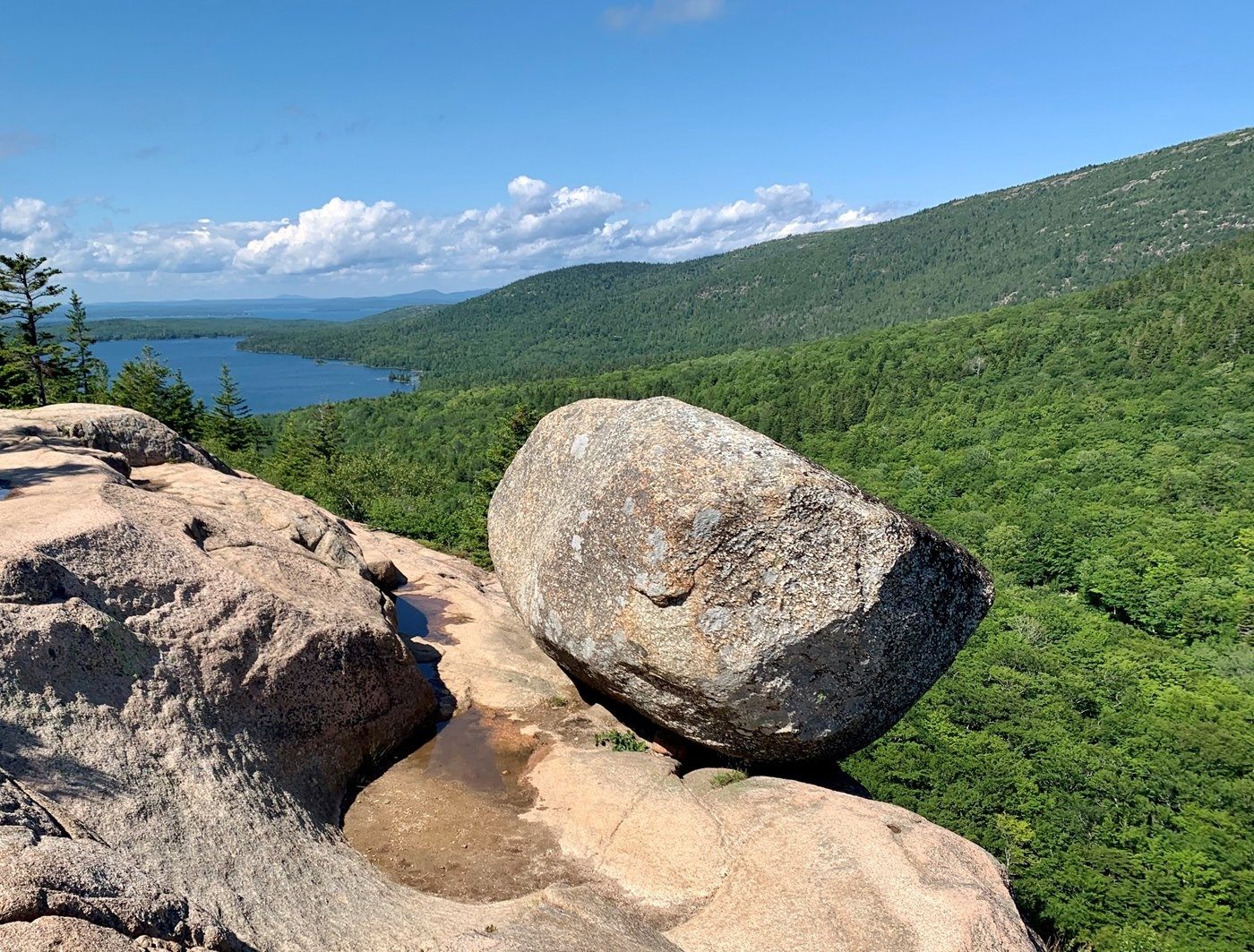
Bubble Rock is a boulder left behind by glacial ice.
NPS/Kylie Caesar · Public domain (U.S. federal government work) · Original recordImage changes
Resized and converted to JPEG for display; no subject alteration.
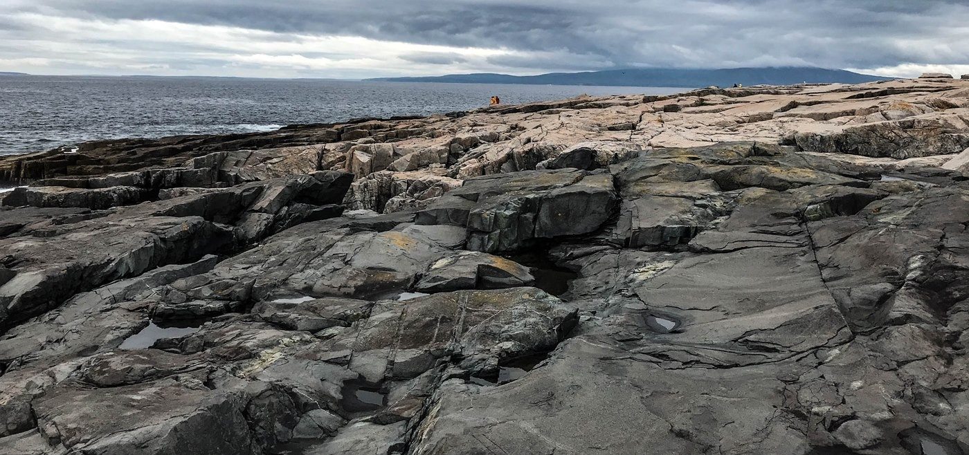
Dark igneous rock cuts through the coast at Schoodic Point.
NPS/ Kent Miller · Public domain (U.S. federal government work) · Original recordImage changes
Resized and converted to JPEG for display; no subject alteration.
The words
Bar Harbor
This Mount Desert Island town takes its name from the sandbar that surfaces at low tide, leading to the park’s Bar Island. After painters made the island famous in the mid-1800s, it became a summer resort for the wealthy.
Did you know?
Until 1918 the town was called Eden. Its 1796 incorporation document was signed by Samuel Adams, then governor of Massachusetts, of which Maine was still a part.
Town of Bar Harbor: the sandbar (opens a new tab) · Park Service: Bar Island Trail (opens a new tab) · Wikipedia: Bar Harbor, Maine (opens a new tab) · Park Service: Rusticators and early tourism (opens a new tab) · Bar Harbor Historical Society: town history (opens a new tab) · Park Service: Samuel Adams (opens a new tab) · Wikipedia: District of Maine (opens a new tab)
Bubble Rock
A glacial erratic: a rock carried by a glacier and left on bedrock of a different kind.
A rounded boulder perched at a cliff’s edge on South Bubble, one of the twin peaks north of Jordan Pond. Glacial ice carried it here, wore off its sharp edges and dropped it as the ice melted.
Did you know?
It isn’t local stone. Bubble Rock is Lucerne Granite, which formed about 30 miles (48 km) northwest of Acadia, so the ice hauled this 100-ton (91-tonne) boulder, the size of a minivan, all that way.
Park Service: Bubble Rock (opens a new tab) · Park Service: Geologic features (opens a new tab)
Cadillac
Short for Cadillac Mountain, Acadia’s tallest peak at 1,530 feet (466 m). Settlers called it Green Mountain until 1918, when it was renamed for the Frenchman granted land on Mount Desert Island in 1688.
Did you know?
That Frenchman, Antoine Laumet, gave himself the title Sieur de la Mothe Cadillac and later founded Detroit. The Cadillac car company, founded there, adapted the crest he designed for himself as its emblem.
Park Service: Cadillac Mountain (opens a new tab) · Park Service: Secrets of the Summit (opens a new tab) · Park Service: Antoine de la Mothe Cadillac (opens a new tab) · Park Service: Colonization and settlement (opens a new tab)
Carriage Roads
These 45 miles (72 km) of roads were the gift of John D. Rockefeller Jr. and his family. A skilled horseman, he built them from 1913 to 1940 for motor-free carriage travel into the heart of Mount Desert Island.
Did you know?
The large granite blocks that line the roads as guardrails, cut roughly and spaced irregularly for a rustic look, are affectionately called “Rockefeller’s teeth.”
Park Service: Carriage roads and gatehouses (opens a new tab)
Champlain
Short for Champlain Mountain, whose once-impassable east-face cliffs carry the Precipice Trail. Formerly Newport Mountain, it was renamed for Samuel de Champlain, the French royal cartographer who explored this coast in 1604.
Did you know?
Peregrine falcons had vanished from the Northeast before the 1960s. After a reintroduction program began in 1984, the first pair nested successfully on Champlain’s east face in 1991. As of 2026, the Precipice Trail closes each nesting season to protect them.
Park Service: Samuel de Champlain (opens a new tab) · Park Service: Historic trails (opens a new tab) · Park Service: Peregrine closures, 2012 (opens a new tab) · Park Service: Precipice Loop hike (opens a new tab)
Isle au Haut
French for “High Island,” the name Samuel de Champlain gave it.
Acadia manages half of this island, reached by passenger-only ferry from Stonington. Heirs of the founder of its 1880s summer community gave land to the park in 1943; the private half holds a year-round fishing community.
Did you know?
Prized by visitors for its solitude, the park’s part of the island has limits: a 2014 plan set a capacity of 128 visitors a day and kept a policy of not promoting it to other park visitors unless they ask.
Park Service: Isle au Haut (opens a new tab) · Park Service: Isle au Haut plan, 2014 (opens a new tab)
Jordan Pond
Acadia’s deepest lake, at 150 feet (46 m), is dammed by an end moraine, a ridge of glacial rubble. It is named for brothers George and John Jordan, who logged here from 1840 and ran a sawmill on its outflow.
Did you know?
Canoes and kayaks may go out on Jordan Pond, but swimmers may not: the pond is Seal Harbor’s drinking water supply.
Park Service: Jordan Pond (opens a new tab) · Park Service: Bubble Rock (opens a new tab) · Park Service: The Jordan brothers (opens a new tab)
Mount Desert
Short for Mount Desert Island, where wealthy residents bought and donated land for Acadia. Champlain named it in 1604 for its bare, rocky summits. Wabanaki people called it Pemetic, which Park Service pages translate as “range of mountains” or “the sloping land.”
Did you know?
Champlain arrived 16 years before the Pilgrims landed at Plymouth Rock, so this land was known as New France before it became New England.
Park Service: Founding Acadia (opens a new tab) · Park Service: Colonization and settlement (opens a new tab) · Park Service: A History of Acadia (opens a new tab) · Park Service: Wabanaki Nations (opens a new tab)
Otter Cliff
These granite sea cliffs, scarred by glaciers, form the highest point on the Ocean Path and draw rock climbers. Like nearby Otter Point, they were most likely named for river otters; Acadia has no sea otters.
Did you know?
During World War I a Navy radio station here, which the Park Service calls the most important for receiving transatlantic messages, picked up Germany’s first message to President Wilson about an armistice on October 6, 1918.
Park Service: Ocean Path (opens a new tab) · Park Service: Geologic features (opens a new tab) · Park Service: Climbing in Acadia (opens a new tab) · Park Service: Sand Beach to Otter Point (opens a new tab) · Park Service: Otter Cliffs radio wayside (opens a new tab) · Wikipedia: 1918 Armistice (opens a new tab)
Popovers
Jordan Pond House, at the south end of Jordan Pond, has served tea and popovers since the 1890s, and afternoon tea on its lawn remains a popular tradition with park visitors.
Did you know?
Popovers joined the menu in 1895, when new owners Thomas and Nellie McIntire added them, with chicken dinners, lobster stew and ice cream, to suit wealthier travelers.
Park Service: Jordan Pond House (opens a new tab) · Park Service: Tea, Popovers, and Tradition (opens a new tab)
Sand Beach
Acadia’s largest sandy beach lies in Newport Cove, where the headland of Great Head and an offshore ledge called Old Soaker calm the surf enough for fine sediment to settle. The water normally runs 50 to 60°F (10–15°C).
Did you know?
Shell from barnacles, mussels and similar creatures makes up 70 to 80 percent of its sand. The Park Service says it is one of only two Atlantic beaches north of Cape Hatteras with both dunes and shell sand.
Park Service: Sand Beach (opens a new tab) · Park Service: Sand Beach to Otter Point (opens a new tab) · Park Service: Geologic story of Sand Beach (opens a new tab)
Schoodic Point
At this windswept, rocky point on the Schoodic Peninsula, the only part of Acadia on the mainland, huge granite ledges turn Atlantic waves into “lofty geysers,” while dark dikes, once-molten rock that filled cracks, stripe the pink stone.
Did you know?
The land came from the family of John Moore, a Maine-born businessman who pictured a summer recreation area here in the 1890s. It joined the park in 1929, the year the park took the name Acadia.
Park Service: Schoodic Point (opens a new tab) · Park Service: Schoodic Peninsula (opens a new tab) · Park Service: Visiting Schoodic (opens a new tab) · Park Service: Schoodic wayside tour (opens a new tab) · Park Service: Founding Acadia (opens a new tab)
Somes Sound
This five-mile (8 km) bay, carved by glaciers, nearly divides Mount Desert Island in half. It is named for Abraham Somes, who settled his family at its head in 1761, at what became Somesville.
Did you know?
Once considered a fjord, it is technically a fjard, the Park Service says: a smaller glacier-carved bay drowned by the sea. From seafloor to summits it measures about 1,000 feet (300 m); Norway’s fjords reach more than 3,280 feet (1,000 m).
Park Service: Somes Sound wayside (opens a new tab) · Park Service: Somes Sound geology (opens a new tab) · Wikipedia: Somes Sound (opens a new tab)
Thunder Hole
Waves rushing into this narrow inlet on Mount Desert Island’s rocky eastern shore force out trapped air with a thunderous boom, best heard one to two hours before high tide. Spray can top 40 feet (12 m).
Did you know?
Beside its parking lot stands the park’s first ranger station, a rustic New Deal-era building from the 1930s that became a gift shop in the late 1960s.
Wabanaki
“People of the Dawnland,” the shared name of the Maliseet, Mi’kmaq, Passamaquoddy and Penobscot peoples.
Acadia lies in the Wabanaki homeland, inhabited “since time immemorial.” The Park Service says Wabanaki people shaped its history “in the face of the colonial onslaught of guns, disease, and attempted genocide,” and that they “are still here.”
Did you know?
In July 2024 the Park Service cleared the way for each of the five federally recognized Wabanaki tribes in Maine, including two Passamaquoddy tribes, to make its own agreement to gather sweetgrass in Acadia for traditional purposes.
Park Service: Wabanaki Nations (opens a new tab) · Park Service: Sweetgrass gathering, 2024 (opens a new tab)
Sources
- Acadia Earthcache Course Stop Two: Bubble RockNational Park Service
- Cadillac Mountain - Acadia National ParkNational Park Service
- Carriage Roads and Gatehouses - Acadia National ParkNational Park Service
- Historic Trails - Acadia National ParkNational Park Service
- Jordan Pond - Acadia National ParkNational Park Service
- Sand Beach to Otter Point - Acadia National ParkNational Park Service
- Wabanaki Nations - Acadia National ParkNational Park Service
- The "Bar" of Bar HarborTown of Bar Harbor, Maine
- Hike Bar Island TrailNational Park Service
- Art, Rusticators & Early Tourism - Acadia National ParkNational Park Service
- Town HistoryBar Harbor Historical Society
- Bar Harbor, MaineWikipedia
- Samuel AdamsNational Park Service
- District of MaineWikipedia
- Geologic Features and Formations - Acadia National ParkNational Park Service
- Secrets of the SummitNational Park Service
- Antoine de la Mothe CadillacNational Park Service
- Colonization and Settlement - Acadia National ParkNational Park Service
- Samuel de ChamplainNational Park Service
- Precipice and other trails closed for peregrine falcons - Acadia National ParkNational Park Service
- Hike Precipice LoopNational Park Service
- Isle au Haut - Acadia National ParkNational Park Service
- National Park Service Completes Visitor Use Management Plan for the Isle au Haut District - Acadia National ParkNational Park Service
- The Jordan BrothersNational Park Service
- Founding Acadia - Acadia National ParkNational Park Service
- A History of AcadiaNational Park Service
- Hike Ocean Path TrailNational Park Service
- Climbing - Acadia National ParkNational Park Service
- Wayside: "Hot Line" to EuropeNational Park Service
- Armistice of 11 November 1918Wikipedia
- Jordan Pond HouseNational Park Service
- Wayside: Tea, Popovers, and TraditionNational Park Service
- Sand BeachNational Park Service
- The Geologic Story of Sand BeachNational Park Service
- Schoodic PointNational Park Service
- Schoodic PeninsulaNational Park Service
- Schoodic Peninsula - Acadia National ParkNational Park Service
- Wayside Audio Tour of Schoodic Peninsula - Acadia National ParkNational Park Service
- Wayside: Seawater BayNational Park Service
- Acadia Earthcache Course: Stop One - Somes SoundNational Park Service
- Somes SoundWikipedia
- Thunder HoleNational Park Service
- Gathering of sweetgrass for traditional purposes moves forward at Acadia National Park - Acadia National ParkNational Park Service